"From the USSR's Be On Guard! map in 1921 to Google Earth, a new
exhibition at the British Library charts the extraordinary documents that
transformed the way we view the globe forever"
 1- BE ON GUARD! 1921
The infant USSR was threatened with invasion, famine and social unrest.
To counter this, brilliant designers such as Dimitri Moor were employed to
create pro-Bolshevik propaganda.
Using a map of European Russia and its neighbours, Moor's image of a
heroic Bolshevik guard defeating the invading 'Whites' helped define the Soviet
Union in the Russian popular imagination.
2- HENRICUS MARTELLUS WORLD MAP, 1490

It's said that Columbus used this map or one like it to persuade Ferdinand
of Aragon and Isabella of Castile to support him in the early 1490s.
The map was made by a German cartographer living in Florence and
reflects the latest theories about the form of the world and the most accurate
ways of portraying it on a flat surface.
It seemed to prove that, as Columbus argued, there wasn't a great distance
between Europe and China by sea. The map is also the first to record the rounding of the Cape of Good
Hope in South Africa by the Portuguese in 1488.
This proved that there wasn't a land link to Asia in the south - and
that Europeans could reach the riches of the East Indies by sea without having
to go through Muslim-held lands.
3- CHINESE GLOBE, 1623
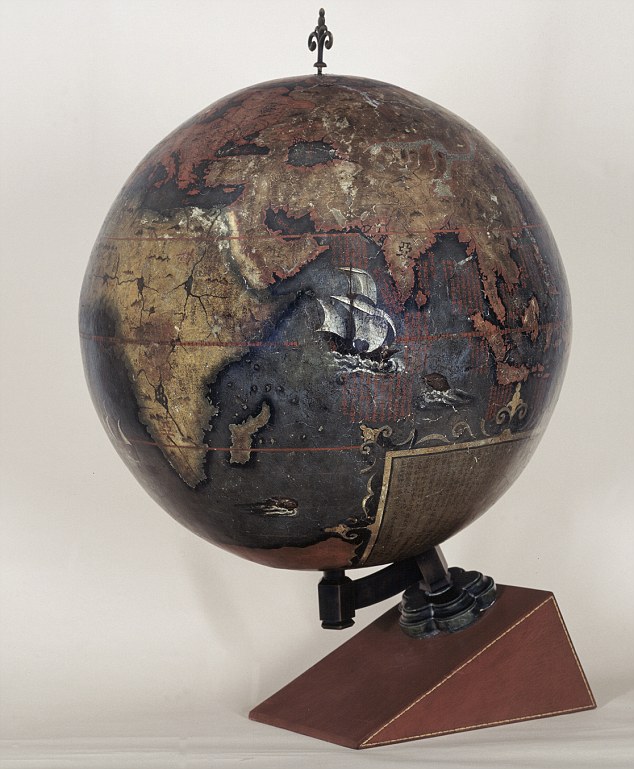 Made for the Chinese Emperor, this is the earliest known Chinese
terrestrial globe, and a fusion of East and Western cultures.
Made for the Chinese Emperor, this is the earliest known Chinese
terrestrial globe, and a fusion of East and Western cultures.
Its creators are thought to be the Jesuit missionaries Manuel Dias
(1574-1659), who introduced the telescope to China, and Nicolo Longobardi
(1565-1655), superior general of the China mission.
Both were respected scholars, and the globe's depiction of the coasts of
Africa and Europe would have contrasted with traditional Chinese maps.
These exaggerated the size of China and placed it in the middle of a
world that otherwise consisted mainly of small offshore islands. In its treatment of eclipses and meridians and its information about
magnetic inclination, however, the globe draws on ideas that were developed in
China far earlier than in the West.
4- WALDSEEMULLER WORLD MAP, 1507
 'America' is named and envisaged as a separate continent for the first
time on this map, put together by a think tank in Saint-Dié in the Duchy of
Lorraine.
'America' is named and envisaged as a separate continent for the first
time on this map, put together by a think tank in Saint-Dié in the Duchy of
Lorraine.
The map itself was created by a skilled cartographer, Martin
Waldseemüller, and was accompanied by an explanatory booklet by one Matthias
Ringmann. Impressed by the writings of Florentine navigator Amerigo Vespucci,
Ringmann suggested that the Americas weren't part of Asia, as Columbus thought,
but a continent in their own right.
So they should, like the other continents, have a female name - hence America, after Vespucci's first name. Perhaps to emphasise the independent existence of the Americas, the map shows what we now know is the Pacific lapping the western coast of South America, though its existence was only confirmed years later.
5- GOOGLE EARTH, c2005

Google Earth presents a world in which the area of most concern to you
(in this instance, Avebury in Wiltshire) can be at the centre, and which - with
mapped content overlaid - can contain whatever you think is important.
Almost for the first time, the ability to create an accurate map has
been placed in the hands of everyone, and it has transformed the way we view
the world. But it comes at a price.
There are few, if any, agreed standards about what should be included,
and the less populated and 'less important' regions get ignored.

Businessman Charles Booth was sceptical about a claim in 1885 that a
quarter of Londoners lived in extreme poverty, so he employed people to
investigate.
They found the true figure was 30 per cent. The findings were entered
onto a 'Master Map' using seven colour categories, from black for 'Lowest
class, semi-criminal' to gold for wealthy. The authorities were terrified into action, and the first council houses
were built soon afterwards.
7- 'RED LINE' MAP OF NORTH AMERICA, 1782-3
 This map was used by British diplomats negotiating an end to the
American War of Independence in Paris. Richard Oswald, secretary to the
delegation, annotated it with coloured lines to show where it was thought past
treaties established the U.S./Canada border.
This map was used by British diplomats negotiating an end to the
American War of Independence in Paris. Richard Oswald, secretary to the
delegation, annotated it with coloured lines to show where it was thought past
treaties established the U.S./Canada border.
In the event, when drawing the northern border the Americans asked for
less than expected, and in the century afterwards they tried to renegotiate.
To prevent them from seeing this embarrassing map, it was removed from
the British Museum, where it had been since the 1820s, and placed in the
Foreign Office.
8- LONDON TUBE MAP, 1933

Dismissed as too 'revolutionary' when it was first submitted in 1931,
Harry Beck's Underground map solved the problem of how to represent clearly and
elegantly a dense, complex interweaving of train lines.
Placing the stations at similar intervals regardless of their true
locations amplifies the area of central London, increasing its clarity, while
the straight lines and interchange symbols confer a simplicity and order on the
network. A cartographic icon.
9- PETERS PROJECTION WORLD MAP, 1974

It's impossible to portray the reality of the spherical world on a flat
map. The familiar 'Mercator' projection gives the right shapes of land masses
(up to a point), but at the cost of distorting their sizes in favour of the
wealthy lands to the north.
The German Arno Peters sought to correct this. His projection gets the
proportions (roughly) right, and has the e‑ffect of emphasising the Third
World. That said, it's no more 'true' than the 'colonialist' projection it seeks
to replace.
10- EVESHAM WORLD MAP, c1400
 Created for the prior of Evesham Abbey, this map marks the birth of
modern English patriotism.
Created for the prior of Evesham Abbey, this map marks the birth of
modern English patriotism.
The top is a world map in the traditional medieval sense, with the
Garden of Eden, the Tower of Babel below and a large multi-towered Jerusalem.
But at the bottom an enormous England stretches from Scandinavia to the
Mediterranean. The very large tower above the French coast is Calais, captured
in 1347. We are in the age of Henry V and Agincourt.


Great job Adri!!!
ResponderEliminarAmazing exhibition, these maps deserve to be remembered. My favorite is the first one, is very creative and unique. Be on Guard!, the URSS was a very popular country.
ResponderEliminarThe London Tube map is my second favorite, was very useful for travelers.
In the exhibit of top ten maps greatest the world, include ten maps important, inter those stand out, the Evesham World Map,1400 Created for the prior of Evesham Abbey, it is more antique than others top ten maps. And the more recent is Google Earth, 2005. It have the ability to create an accurate map has been placed in the hands of everyone, and it has transformed the way we view the world.
ResponderEliminar-Ten of the best maps that changed the world is a very interesting topic and I agree friend Joel Oliviera, these should be remembered at all.
ResponderEliminarThose who really caught my attention were:
* "GOOGLE EARTH, c2005" is known, but yet here we can read and specify in more detail about this.
* "DESCRIPTIVE MAP OF LONDON POVERTY, 1889" that's pretty striking because it shows that by then there was a quarter of Londoners who lived under extreme poverty.
*Oh and the "LONDON TUBE MAP, 1933" you can say that is super useful for travelers. (It would serve as a guide for them).
Annielys Rivero.
The maps changes our live since they were created. Each map made whith different creativity, some more advance than others, one correct and some incorrect but both useful for our future.
ResponderEliminarThe ones I liked were:
~ Chinese Globe (1623): they were the first to made a spherical map.
~ London Tube Map (1933): this map represent a good complex interweaving of train lines.
Jesús Carvallo.
Add to these ten, we have even more tales of old maps that come in the cartographic history. As were the older maps that exist were made by the Babylonians about 2300 a.c bThese maps were carved on clay tablets and consisted mostly of land measurements carried out to collect the taxes. Also found in China more extensive regional maps, drawn on silk, dating from the second century a.c Eratosthenes around 200 a.c. Represented the known world from Britain, to the northwest, the mouth of the river Ganges, east, and south to Libya. This map was the first in which transverse parallel lines appeared to mark the points with the same latitude. The map also appeared some meridians, but they were spaced irregularly.
ResponderEliminarIt is considered that the map made in 1507 by Martin Waldseemüller, German geographer, was the first to designate the name of America to the newly discovered lands transatlantic. For the year of 1508 is recognized by America Américo Vespucio through expedition trips. Already by 1879, the United States was organized geological studies in order to make large-scale topographic maps across the country. In 1891, the International Geographical Congress proposed to map the entire world to a scale of 1:1,000,000, a task that is not yet completed. In the twentieth century Cartography has experienced a number of technical innovations. The photo area was developed during World War I and was used, more widely, in mapping during World War II. The United States, which launched in 1966 and continued Pageos satellite in the 1970s with the three Landsat satellites, geodetic studies are full of the land surface by high-resolution photographic equipment placed in these satellites. An example of this was the creation in 2005 of the tool google earth, which sought greater precision mapping and where any user could access to obtain a spatial location easily.
It´s a very interesting subject, because with those ten maps we can build again the history, we can imagine how people thought a few centuries ago. And watch the growth on the elaboration of maps. Also I´ll name the maps I liked most:
ResponderEliminarNumber three: Chinese Globe, it is the first round representation of the world, in contrast to the custom flat representation. It innovated the current way to represent the world.
Number five: Google Earth, it´s a very useful tool, a good way to offer images of the world to everyone, and it’s totally real information, because thanks to the satellites we can observe the world exactly the way it is. The only thing is that it´s images aren’t updated. Generally are from a few years ago, never from de current year.
Number Six: Descriptive map of London Poverty, it´s a theme map, the kind of maps we often elaborate. Starting with a cartographic base, it’s a good way to unite information and took out conclusions with the objective of improving cities, states, countries.
To finish I consider that would be interesting to add a geomorphologic map, because between the ten maps shown before, don´t show information about it. And it could be interesting to see the formations and the movements of plaques around the world.
Excellent article mate, I'm happy to see maps that changed the history of humanity, as the number 2, where thanks to the Colon was able to convince the kings of Spain to fund his journey, or map number 5, thanks to GOOGLE EARTH could make available to all maps of any region in the world with just one click.
ResponderEliminarParra Ángel.
Today's results are a product of the past absolutely, and an example of that are these ten maps, which are very important in the story. Each map is a contribution to mapping because from it has been able to evolve in this area from each of the geographical and social phenomena of history. One of the maps that I found interesting was the map drawn by the cartographer Waldseemüller in 1507, because that was where he first gave the name America to Europe. I agree with Daniela Fuentes about Google Earth (2005) is very useful, because besides this tool you can generate good quality images. It's great that maps of different continents have set an important mark in the evolution of drawing maps, because it shows that it is very important to study the comparison of one region to another.
ResponderEliminarToday's results are a product of the past absolutely, and an example of that are these ten maps, which are very important in the story. Each map is a contribution to mapping because from it has been able to evolve in this area from each of the geographical and social phenomena of history. One of the maps that I found interesting was the map drawn by the cartographer Waldseemüller in 1507, because that was where he first gave the name America to our continent. I agree with Daniela Fuentes about Google Earth (2005) is very useful, because besides this tool you can generate good quality images. It's great that maps of different continents have set an important mark in the evolution of drawing maps, because it shows that it is very important to study the comparison of one region to another.
EliminarKehilin Goncalves:
ResponderEliminarI find really interesting about this song called ten of the greatets: maps that changed the word, and also the various ways in which these maps are represented. also would like to add the following web
http://www.amazon.com/Map-That-Changed-World-William/dp/0061767905.
which says:
In 1793, a canal digger named William Smith made a startling discovery. That I have found by tracing the placement of fossils, que've uncovered in his excavations, one follow layers of rocks Could Peak Gust dipped and rose and fell clear across England and, indeed, clear across the world making it possible, for the first time ever , to draw a chart of the hidden underside of the earth. Smith spent twenty-two years piecing together the fragments of this unseen universe to create an epochal and remarkably beautiful hand-painted map. But instead of Receiving accolades and honors, I ended up in debtors' prison, the victim of plagiarism, and virtually homeless for ten years more.
The Map That Changed the World is a very human tale of endurance and achievement, of one man's dedication in the face of ruin. With a keen eye and thoughtful detail, Simon Winchester unfolds the poignant sacrifice behind this world-changing discovery.
Henry Fernàndez:
ResponderEliminarEs increíble ver como a medida que pasan los años los mapas se han ido desarrollando cada vez mas y gracias a la tecnología, desde la llegada de google earth ha sido un gran avance. de igual forma acotare un poco mas de informacion sobre el mapa que mas me impresiono;
Henricus Martellus Germán es el nombre latinizado de Heinrich Hammer , un alemán cartógrafo que vivió y trabajó en Florencia desde 1480 hasta 1496.
Alrededor de 1489 o 1490, produjo un mapa del mundo que era muy similar a la terrestre globo tarde producido por Martin Behaim en 1492, el Erdapfel . Ambos muestran fuertes influencias de Ptolomeo , y ambos posiblemente derivan de mapas creados en torno a 1485 en Lisboa por Bartolomé Colón .
Uno de sus dos mapamundis manuscritos, 201 cm x 122 cm de tamaño, redescubiertos en 1960, fue donado a la Biblioteca Beinecke de Libros Raros y Manuscritos . [1]
El otro manuscrito semejante mapa del mundo se encuentra en la Biblioteca Británica . [2]
Martellus también en 1484 produjeron un Insularium Illustratum , o un libro de las islas, que contenía mapas. [3]
It`s Amazing to see how cartography has envolved! From the earliest days of the humanity, we felt the need to know all about the place we live, and with all this maps, I can prove all what I'm saying. Thanks to these cartographers we have a big technological development, that allows to us to see the world just like the way it is.
ResponderEliminarYou can notice the cartography has evolved with the passing of the years and the different uses to which it can give maps with technological advances of our time we have accseso makes it easier to map and one of the type tools more useful for this work is GOOGLE EARTH, c2005.
ResponderEliminarMy Favorite is the Chinese Globe for their job on the graphics in the material and the movility gave the object. We need us give the value that deserve the cartography for you practicality and aplication in the world.
ResponderEliminarI found it interesting how much we have improved our knowledge in cartography, compared to the first map we found in this article, now we can be more specific or even theme like it is shown in the London Poverty Map.
ResponderEliminarMy favorite one was the London Tube map, because it was an amazing idea for that time , and people didn't understand and called it "too revolutionary" and even though it was done in a very simple way to make everybody who use it feel comfortable.
Marian Marañon
On the issue of google earth, to open the program! True!! Always highlight cities, sectors, localities (urbanism) that stand out as dynamic sites that show the diversity of infrastructure, all with the purpose of showing the quality and functionality of this application that every day includes many tools that enable the user to perform various searches, routes, routes, calculations of areas and a number of spatial tasks from planning to tour the streets in 3d, this app is very useful and with the passage of time will continue adding more functions as input should of toponyms incorporate more accurately because in the hydrography has many flaws in the names of rivers. Edgardo Piñango...
ResponderEliminarIn the mapping technology is has certainly come a long way with the passing of the years. The first maps were drawn by hand with pen on parchment, what their quality varied greatly, but each time the man will adapt with knowledge and tools at your fingertips, so you can not demand more than what you have . The program Google Earth or Google Maps is now the most effective navigation map, but to reach this went a long way allowing experiences now have almost a perfect model of the reality on the ground. But I doubt that following the years passed cartographic technology systems we know today will be a shadow of what is considered perfect because of the extraordinary technological developments that will exist in the near future. So I admire the work of each ancient mapmaker, that even having little information on actual field let your imagination and common sense to get too in a role as it is in reality.
ResponderEliminarEste comentario ha sido eliminado por el autor.
ResponderEliminarInteresting article about the evolution of cartography, it is important to highlight the intention at each time for different countries and authors, the idea of capture according to the historical moment each of those spaces with their forms, necessary for humans over time as tool's location on the Earth's surface; and that with the passage of time by the need for a greater accuracy and usefulness are created more advanced techniques as it is the case of Google Earth. Vaneska Marcano-Alvarez.
ResponderEliminarIn my opinion these ten maps show us how outset maps and cartography have been an important part in the history of man, as well as improved the preparation of these up to make a view about how we see the world .
ResponderEliminarIt can be seen that initially the maps could have a use different from today as seen in the first Be on Guard!, also observed that could be used to enhance to the country where they elaborated as in the case of chinesse Globe in which exaggerated both their size and their location to place it in the middle of this.
Also see how they got other uses to negotiate, or the construction of the railway line.
When viewing the ten maps detail, it is interesting to see how the centuries through cartographic records of the past years even're still current basis for the elaboration of these.
ResponderEliminarAt present there tools technology by facilitating the elaboration of maps such as Google Earth by satellites which provides detailed images of the entire surface of the earth.
Article is very interesting because it explains the origins of the first world history maps, highlighting the 10 maps are more important as 1921 Be on guard in this highlights some of the ancient history of the Soviet union where it shows Bolsheviks was in support of pro-Bolshevik culture. LONDON MAP DESCRIPTION OF POVERTY, 1889 This second map is really interesting because it describes different colors by the different social classes that existed in London, these maps mentioned were the ones I drew attention for its historical pofundidad in europe this is noted as important has technology and human work in progress search guided cartographic maps.
ResponderEliminarIn this article the map that most caught my attention is that of the London Underground lines. It is impressive to see how the Europeans have established their transport system almost from the beginning of the twentieth century. Also you can see that since that time had several lines within the system.
ResponderEliminarAnother maps that I find extremely edgy is google earth, although my opinion does not count as a map, but rather think it is a digital geography tool or a kind of GIS, which all have used even once.
It is important to see how man has developed his knowledge throughout history, and even more to see how progress has been made in building the tools that help you understand time and space, which is quite complex in which to make geography.
VERY GOOD COMMENT BY ANGEL PARRA BECAUSE HE'S VERY INTELLIGENT AND A BEUTIFUL PERSON. GOOD JOB ANGEL!
ResponderEliminarWOW we have a fan of Angel Parra. This is the height
Eliminar